Precise positioning services in the Surveying and Land Management sector (2013)

Overview

The position requirements of surveying are one of the most demanding of all of the land related activities. The cadastre, which is the spatial, textural and temporal record of property in Australia, requires centimetre accuracy. Similar levels of accuracy requirements arise for surveying and setting out of infrastructure and in land development.

The surveying sector has been an early adopter of augmented GNSS. Surveyors use augmented GNSS in combination with other geospatial technologies to support accurate location of points in setting out engineering and other infrastructure. This saves significantly on labour costs reducing the number of surveyors and technical staff required on site.

Geographical scope

Australia

Non-quantified impacts

Important applications of augmented GNSS include regional surveys where the availability of control benchmarks is limited, engineering surveys, accurate sea level monitoring, infrastructure condition surveys and sub-divisions. Augmented GNSS is also actively used by the offshore sector in geophysical surveys.

Productivity improvements are significant in surveying and land management, ranging from about 20 per cent to 40 per cent in 2012 with a further 20 per cent likely by 2020.

Levels of adoption of augmented GNSS in the surveying sector are estimated to have been around 20 per cent in 2012.

Quantifiable impacts

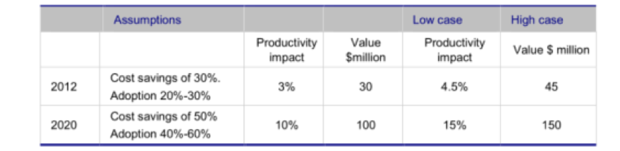
The report estimates that in 2012, augmented GNSS had delivered cost savings to the surveying and land management sector of between AUD 30 million and AUD 45 million. These savings are projected to increase to between AUD 100 million to AUD 150 million by 2020. These estimates are based on conservative assumptions on the rate of development of CORS networks.

Productivity improvements for surveying in the construction market.

Reference

Region

Study type

Case studies and CGE modelling

Economy sector

Real Estate and Land Administration