The report aims to estimate the potential economic benefits that Geospatial Information and Technologies (GIT) could contribute to the economy of the Kingdom of Saudi Arabia (KSA). The General Authority for Survey and Geospatial Information (GASGI) has oversight of the geospatial sector in KSA and asked the World Bank to carry out the study.
KSA’s economy is the largest in the Gulf Cooperation Council (GCC) with an estimated GDP of USD 782.5 billion in 2018. The Kingdom has the largest proven oil reserves globally and is the largest worldwide oil producer. However, in 2016, KSA announced Saudi Vision 2030—an ambitious plan and strategic blueprint to diversify the country’s economy and transition away from its extractive industries.
The particular focus of the report is on how Geospatial Information (GI) will play a fundamental role in supporting the growth and development of key sectors identified by Vision 2030. These sectors include commerce (ports), infrastructure (roads), energy, health, education, public safety and security, and disaster risk management. The sectors are expected to enhance KSA’s market, strengthen sustainable economic growth and help the country shift away from oil dependence.
KSA is a heavy user of geospatial data, especially across government and within the oil and gas, utilities and telecommunications sectors. The country’s growing GIT sector provides a range of services including software and solutions development, consumer services, cartographic services and supports major multinational companies across the Kingdom’s industries. Nevertheless, the business capacity of the geospatial sector in KSA is relatively limited and currently only comprises a small fraction of the local market. KSA is working towards the creation of a national strategy for the geospatial sector which will include the development of a Spatial Data Infrastructure (SDI) to support the Saudi Vision 2030 and prioritise investment needs.
A brief introduction of the Saudi Arabian context is given along with the main motives behind the study. The economics of geospatial information is discussed along with the role that government can play in its collection and distribution. The paper’s methodology is then expanded upon followed by the estimates the authors make for the benefits of GIT to each of the identified economic sectors. The reports concluding remarks are provided with recommendations for future research.
Education – GIS tools will support plans to significantly grown KSA’s education sector by offering the ability to reliably identify and analyse the state of the sector and measure progress towards the government’s goals. Mapping data can help authorities make decisions regarding education infrastructure. Increasing school enrolment in KSA will require the expansion of school buildings, GIS enables applications that can bring more efficient information systems to support every stage of construction.
Infrastructure (roads) – despite KSA’s significant investment in developing its large road network there is an estimated backlog of maintenance of roads due to insufficient fund allocation. The poor quality of roads is partially responsible for KSA’s poor road safety record. GIT can provide crucial data on the precise location of assets within the context of the surrounding environment to transform every step of a road project lifecycle: planning, design, surveying, construction, operation and maintenance.
Disaster Risk Management – Saudi Arabia is vulnerable to various types of natural hazards such as costal and flash flooding, extreme heat, water scarcity, dust storms, earthquakes and volcanoes. KSA is increasing efforts to develop a comprehensive Disaster Risk Management (DRM) system. GI-based systems can significantly improve DRM efforts at every stage of the disaster response life cycle. For example, emergency preparedness tools can be improved and adapted to incorporate GIS-enabled functionalities and improve risk mitigation efforts. GIT can also play an important role in maximising the productivity and overall effectiveness of response efforts. Furthermore, GI can support the coordination of relief efforts by helping to identify affected areas with the highest priority needs.
Energy – precise mapping abilities provided by GIT will have significant benefits for energy infrastructure development and expansion in KSA. For example, GIT can support the design of a new power substation by digitising the whole process and enabling 3D digital modelling thereby reducing the time required to develop schematic drawings. GIT can also help to prevent damage to underground utility assets (water mains, power cables, sewage lines, etc.,) that can result from excavations for land development. Further, GIT can also be applied to the renewable energy sector. For example, to assess suitable locations and the technical and economic feasibility of investment in a solar utility plant.
Public Safety – In KSA, the General Directorate for Public Security (Ministry of Interior) has identified the inclusion of new technologies into its organisational operations as part of its stated objectives, with the goal of automating more of its functions and advancing the government’s wider e-government priorities. Geospatial technologies will help meeting these objectives across the range of the Directorate’s remit of protecting lives and property as well as crime detection and prevention.
Public Health – KSA’s the public health sector is overseen primarily by the Ministry of Health (MOH) that is responsible for most of the financing, operations, and management of all health facilities in the Kingdom. The health sector offers a range of possible applications for GI technology. For example, some applications of GI include tracking immunisation programmes, mapping service areas and undertaking health policy research. Geospatial technologies can be used in contact tracing protocols and other critical parts of health infrastructure. For example, monitoring and containing the spread of outbreaks of infectious diseases can be supported by GPS data from phones, cars and credit card transactions as well as CCTV.
Commerce (ports) – GIT and mapping technology offers comprehensive solutions to increase the safety and efficiency of ports. The performance of port equipment can also be improved to reduce disruption to operations with the use of GIT-enabled ‘black boxes’ installed on cargo-handling equipment to ensure that equipment is functioning at high efficiency and is well maintained. Other GI applications that would benefit KSA are digital multi-stakeholder systems that help improve interactions between all port partners. Cloud-based custom systems using smart sensors could also enable the transition away from paper-based systems.
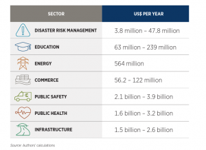
The table below summarises the range of estimated benefits that GI and technologies might be expected to deliver to KSA. These benefits were estimated by using data provided directly by KSA government ministries and agencies, adapting certain assumptions and are subject to limitations and caveats detailed in the report.
Summary of estimated benefits from GI by sector use case
Find this article at:
https://gasgi.gov.sa/Documents/Maps/2022/March/KSA_GEOSPATIAL_ECONOMIC_IMPACT_STUDY.pdf
Our mission statement: We go that bit further to provide our customers worldwide with the best advice on how to maximise the benefits of location information in their business. Our consultants come with location intelligence inside.