Economic Value of Spatial Information in New South Wales (Estimated for 2017 & 2022)

Overview

The Cooperative Research Centre for Spatial Information (CRCSI) has undertaken an assessment of the economic value of the spatial services in New South Wales (NSW) as there exists no regional based economic studies. The request for this assessment came from the then LPI (Land and Property Information) supported by the NSW Location Leadership Group (NSW Spatial Council which comprises representations from all NSW government departments) and the Location Intelligence Industry Advisory Committee. The last study conducted was at a macro level covering the entire country on the value of spatial information by the CRCSI in 2008. The report assesses the value of spatial information to the NSW economy in 2017 and the expected value by 2022. It also estimates the present value of benefits expected to accrue after 2022 from developments in a single digital cadastre and Building Information Modelling (BIM) federated registries. This report draws on case studies and desktop research to estimate productivity impacts of spatial information. These estimates were combined with estimates of levels of adoption across specific industry sectors to estimate the state-wide impacts. It also examines the impact of lives saved in the case of ambulance services. The findings of the report are based on direct benefits of selected case studies and are an indication of first round effects of the use of spatial information and services.

Geographical scope

New South Wales

Non-quantified impacts

Not specified

Quantifiable impacts

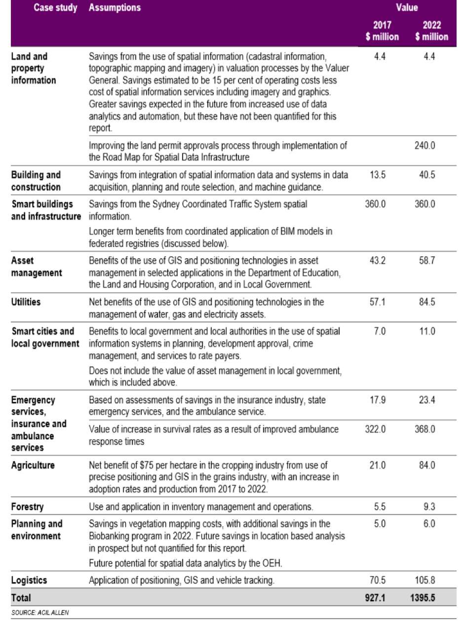
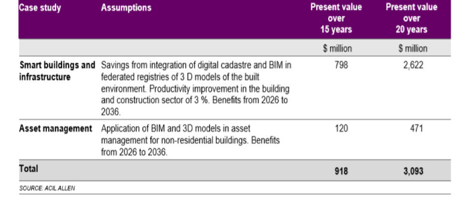
A summary of the net benefits (first figure below) from improvements in productivity attributed to the use of spatial information, services and analytics in NSW shows total net benefits of AUD 923 million in 2017 and AUD 1,395 million expected by 2022. A summary of the net present value of benefits that are expected to accrue between 2026 and 2036 shows additional benefits of AUD 918 million in present value terms, over a period of 15 years, are estimated to accrue from developments in the single digital cadastre and from the integration of the digital cadastre and federated 3D models. If the cash flow is extended to 20 years this value rises to around AUD 3 billion in present value terms. These longer term (figure below) benefits assume that a single digital cadastre is implemented in NSW by 2026 and federation of 3D models of the built environment (including BIM) is achieved. Adoption is assumed to start at 10 per cent in 2026 and reach 70 per cent by 2033.

Summary of benefits in 2017 and 2022


Summary of longer term benefits from digital cadaster and federated 3D models


Reference

Region

Study type

Case studies and desktop research to drive cost-benefit assessment

Economy sector

Infrastructure (Transport), Infrastructure (ICT), Design and Construction, Public Sector Local Government, Public Sector Central Government, Environment, Agriculture